
Heuristic Nolli Map: Representing the Public Domain in Urban Space
Jie-Eun Hwang & Kimberle Koile
What
This study proposes an information technology, which we call a Heuristic Nolli Map, that represents and identifies public domain in urban space. The concept of the Heuristic Nolli Map encompasses the creation of a user's representation of the public domain and the subsequent modification of that representation during the urban design process. It includes a data model, based on GIS data; a typology of characteristics associated with urban types, such as main street, downtown, and mall; and a machine learning classifier, which maps urban characteristics to a measure of "public-ness" for an entity. The Heuristic Nolli Map, by means of these components, provides a methodology for managing and using urban design knowledge in a systematic way.
Why
Public space has been an essential subject for architects, urban designers and planners for centuries. The definition of "public space", which has traditionally meant streets, squares, and parks in an urban context, is a topic of lively debate. We use the term "public domain" and define it as all places that are perceived as public—streets, squares, parks, as well as privately managed collective spaces that still function as public space [1]. To represent and reason about the public domain, modern urban planners have adopted an approach first demonstrated in 1748 by Giovanni Battista Nolli with his elaborate plan-map of Rome. With this map, Nolli created a unique view of a city as a mosaic of public and private spaces, with boundaries defined not only by streets and parks, but also by privately owned interior public spaces. In the figure below, private areas are rendered in dark gray, public areas are white and represent paving, vegetation, etc., as well as public interior spaces. This representation describes the experience of moving around in the city, rather than the distinction between the built and unbuilt environment.
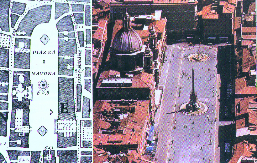
Figure 1 (a: Left) Piazza Navona in Nolli’s Roman, (b: Right) Piazza Navona
The Nolli map has proven a powerful instrument for urban design and study. The modern Nolli map, however, has two problems: (1) it remains primarily a graphical visualization similar to Nolli's map of 250 years ago despite the advantages afforded by computer-aided design tools and Geographic Information System (GIS) technology; and (2) it does not take into account the wealth of data available to modern urban designers and planners. As Leong points out, "No longer is the city visualized or composed as much as it is empirically computed" [2]. The amount of data available for such empirical computation is overwhelming, but new information technology can be brought to bear on this problem.
How
The Heuristic Nolli Map includes a data model and a machine learning component. The data model contains Geographic Information System (GIS) data of three sorts commonly available in United States cities: land parcel, building footprint, and street centerline. Overlaid onto this data is attribute data such as that gathered from tax assessment databases. The addition of this data allows a finer granularity of representation than is available with GIS data alone. It is not sufficient, for example, to represent only a building's footprint if the goal is to identify the "public-ness" measure of the building; we also need characteristics such as building type, number of stories, and facade material.
The results of the machine learning component are a classifier, which maps urban characteristics to measures of public-ness for particular entities; and a user's customized typology of the public domain. By typology, we mean types of entities in the public domain, e.g. main street, and the characteristics of those entities that a designer thinks important in identifying public domain. The machine learning component has not been decided upon yet, though we have established guidelines for its design: It will be a data-oriented learning system capable of mining databases for regularities. It will be a supervised learning method, since it will be provided with examples of a user's interpretation of public-ness. It will not be a "black box" statistical learning method, since it will need to provide human-understandable explanations for its classifications.
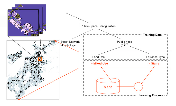
Figure
2. Machine learning component will produce a classifier and human-readable
"rules" representing influence of urban characteristics on measures of
public-ness
Current Status
We will demonstrate our approach by describing the use of a Heuristic Nolli Map in interpreting the public-ness of main streets—typical linear commercial districts in the center of residential areas. This urban type is quite consistent in terms of both physical built environment and socioeconomic function throughout more than 1000 sites nationwide [3]. We have collected data relating to 19 main streets in the Boston area, and have surveyed a group of designers on their intepretation of the public-ness of buildings on one of those main streets. The designers were asked to classify each of 56 shops (in 37 buildings) given three kinds of information:
- 10 layers of information (e.g., commercial property classification, residential property classification, streetscape, building heights, property values)
- 2 sets of panoramic pictures along the street
- 56 pictures of individual shop fronts
We asked them to perform two tasks given a photographic slide show of each of the 56 individual shop fronts and a list of decision criteria:
- designate whether they thought the shop public or not
- mark the factors that contributed to the designation.
The decision criteria were organized into three categories: type of land use or business, patterns of use by people (e.g., number of people, behavior of people), and built form (e.g. distance from street, length of active facade, transparency of front windows).
We found that business type was the most dominant factor in designation of public domain, with built form second. The built form characteristics most often used to identify public buildings were facade materials and signage, architectural style, and transparency of front windows. The data collected relating urban characteristics to a measure of public-ness will serve as training data for our machine learning component.
In this preliminary study, we represented public-ness as a boolean value, either true (1) or false (0). In our next experiments, we plan to use a quantitative representation that will correspond to a measure of "degree of public-ness", i.e., how public a designer considers a building to be. In addition to conducting more surveys with designers, we will continue design of overall system architecture, then design and implement our data model and machine learning component.
This work is being carried out at the Harvard Graduate School of Design and the MIT Computer Science and Artificial Intelligence Laboratory.
References
[1] M. Hajer and A. Reijndrop. In Search of New Public Domain. NAi Publishers, Rotterdam, 2003.
[2] S.T. Leong. Ulterior Spaces. In Koolhass, R., et al (eds), Harvard Design School Guide to Shopping. Taschen, Koln, 2001.
[3] K. A. Robertson. The Main Street Approach to Downtown Development: An Examination of the Four-point Program. Journal of Architectural and Planning Research, 21(1), pp. 55-71, 2004.
The Stata Center, Building 32 - 32 Vassar Street - Cambridge, MA 02139 - USA tel:+1-617-253-0073 - publications@csail.mit.edu (Note: On July 1, 2003, the AI Lab and LCS merged to form CSAIL.) |