
Taxonomy of Landmarks and Spatial Reasoning in Route Representation
Emily Whiting & Seth Teller
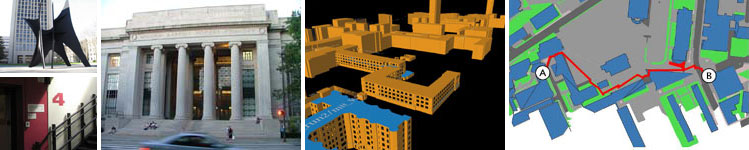
Figure 1: Sources for wayfinding instructions specific to MIT campus:
(left) landmarks on MIT campus; (center) campus model visualization from
BMG project; (right) route
map [1].
Introduction
Landmark-based route representations, describing a path from one location to another, can be a powerful tool for communicating and visualizing directions. Navigational services provide sequences of instructions, guiding the user along the fastest route from one decision point to the next. We investigate the problem of integrating local landmarks into such wayfinding instructions as means to improve spatial reasoning during communication of routes.
Consider the following scenarios: (i) A student needs directions to his professor's office. In a web form, he enters Lobby 7 as the start location, and room 10-491M as the destination. He submits his query and is presented with a composite page containing a route map, images of reference points along the path (each pointing to their location on the map), and text directing him from one landmark to the next. Exiting the elevator, he follows instructions to "turn left at the Steam Cafe into a hall with interior glass walls." As he continues through to building 10, he verifies he has not passed the destination by the "blue neon sign on the left." When he reaches the "red wall" he turns to "ascend the staircase on the right" and "enter the mezzanine" where his professor's office is located. (ii) A visitor to MIT has an appointment at the Media Lab. When submitting her route query she also specifies an interest in art. In addition to functional landmarks, her attention is drawn to the sculptures in Killian Court as she walks through lobby 10.
We wish to generate such landmark-rich route directions automatically. From specified origin and destination points, an algorithm of our own design will generate efficient paths, select the most salient features from a corpus of landmark descriptions, and incorporate these landmarks into the generated route instructions. A decision metric will be formalized for landmark saliency - determining from all available landmarks, the most useful subset for a given route. We analyze landmarks according to such features as singularity (contrast with the surroundings), prominence/visibility, content (having meaning or cultural significance) and prototypicality. In developing this taxonomy of landmarks, there are also implications for understanding spatial cognition. The results may be applied to designing spaces and environments that facilitate the emergence of meaningful and useful landmarks [2].
Approach
The main motivation for this work is to develop an intuitive approach to navigation services. Navigational uses of landmarks consist of: identifying origin and destination points, identifying decision points (points of reorientation, or junctions where current orientation is maintained), verifying route progress, influencing expectation, providing orientation cues, and identifying regional differentiating features [2]. The second motivation is to create a useful service for visitors to MIT, who may easily generate self-guided campus tours tailored to their personal interests. We offer a searchable database, allowing visitors to find "points of interest" on campus, and how to locate them.
A primary challenge is the definition and automatic extraction of landmarks from an existing campus model. Some landmarks fit naturally into the mechanisms developed for describing model geometry in generic walkthrough systems: e.g., interior windows, entranceway dimensions, distinctive floor surfaces or wall colors or textures. Others are perhaps more idiosyncratic. Work has been done on principles for identifying landmarks, such as in [2]. In our case, the reach broadens to include not only visually distinctive elements as landmarks, but also elements that are "of interest to MIT". In other words, objects that will either be occasional destinations in their own right, or to which people might want their attention to be drawn as they proceed on their way elsewhere. In addition to automatic extraction, a collaborative approach to landmark definition will be implemented inviting input from MIT affiliates. Over time, a user-driven resource will be populated of all that is visually noteworthy at MIT.
An integral part of the application will be establishing a grammar for generating human-readable directions. Instructions will employ egocentric cardinal orientation (e.g. front, left, back, right), and a landmark name-resolution utility: name bindings that capture equivalences between numerical, formal and colloquial reference types. Issues of geographical and administrative scoping also come into play for resolving non-unique cases. An additional challenge is to simultaneously collect accurate data on location and visibility/occlusion. Partial visibility information can be computed from known 3D geometry with standard sightline techniques. In areas where this data is missing, visibility may be inferred from principal viewing points, manually specified for each landmark. Finally, a framework for route visualization will be developed, combining information from campus model geometry, path-drawing abstractions, landmarks images and descriptive information.
This work builds on past projects by MIT's Building Model Generation (BMG) group that seeks to parse and interpret semi-structured CAD representations of existing building structure. Three-dimensional metric models extracted in this way serve as underlying data for route-finding and landmark discovery. The existing campus model includes a graph adjacency network representing legal moves through campus via spaces (nodes) and portals (edges). Each location references lists of landmark descriptors: those that are visible from the space, or proximal (geometrically co-located) with it. A client-server architecture has been developed for generating efficient routes between locations on MIT's campus - we will develop a flexible application for this architecture that extracts salient landmarks based on user specified interests and constraints.
References:
[1] P. Nichols. Location-Aware Active Signage. M.Eng Thesis, Massachusetts Institute of Technology, Cambridge, MA, January 2004.
[2] M.E. Sorrows and S.C. Hirtle. The Nature of Landmarks for Real and Electronic Spaces. In Spatial Information Theory. Lecture Notes in Computer Science, Vol. 1661. Springer, Berlin, pp. 37-50. 1999.
[3] M. Raubal and S. Winter. Enriching Wayfinding Instructions with Local Landmarks. In Geographic Information Science. Lecture Notes in Computer Science, Vol. 2478. Springer, Berlin, pp. 243-259. 2002.
The Stata Center, Building 32 - 32 Vassar Street - Cambridge, MA 02139 - USA tel:+1-617-253-0073 - publications@csail.mit.edu (Note: On July 1, 2003, the AI Lab and LCS merged to form CSAIL.) |