| Technical Reports | Work Products | Research Abstracts | Historical Collections |
![]()
|
Research
Abstracts - 2006
|
|
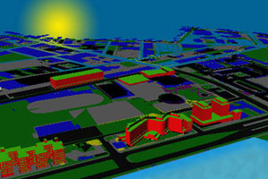
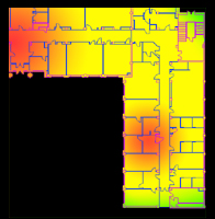
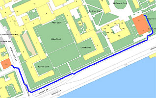
A Robust Geospatial Data Framework and Federation Mechanism for Modeling and Navigating Local EnvironmentsY. Battat, G. Giovine, E. Whiting & S. Teller
Figures: (left) 3D models of MIT buildings
and campus terrain; (center) a visualization of hazardous materials; (right)
route map.
IntroductionThe notion of situational awareness – where we are, where we are going, and how we are getting there – plays a significant role in our daily lives. One way to achieve such situational awareness is by constructing comprehensive models of local environments. Unfortunately, creating such models manually and regularly is infeasible due to the complexity and dynamics of everyday environments. This research project aims to automatically compile feature-rich, geometric and symbolic models of local environments organized from common data sources such as architectural floor plans. The models will then be integrated into human and robotic navigation systems, to the effect of greatly enhancing their usability. We propose to do this by: (1) developing a robust and scalable data representation that exhaustively characterizes geospatial features; (2) defining an interface to access these data in a federated and asynchronous manner for visual and inferential infusion into existing navigation systems; and (3) demonstrating the framework with a prototype application. We further aim to incorporate a number of location-based datasets around the MIT campus into this system. To facilitate the integration of such data, an interface for visualizing and storing geo-referenced information is presently under development. This interface will allow users to enter a single data point or an entire database of information for domains such as equipment tracking, hazardous materials identification (Figure: center), and landmarks of interest on campus. A demonstration of these powerful concepts is available in a prototype developed by our team entitled MIT Wikimap. This project is a collaborative effort to catalogue and share points of interest around the MIT Campus. ApproachThe idea behind Building Model Generation (BMG) is as follows: floor plans (in their native AutoCAD format) are inputted into the BMG pipeline, where the data are processed into a usable geometric format. Further stages of the pipeline subsequently extrude geometric depth from the data, resulting in a high-definition, three-dimensional representation of the local environments (Figure: left). This geometric data is further analyzed for the purpose of deriving a topological layout of the environment in the form of a graph with nodes and edges. Combining this data gives way to applications that can provide virtual tours of a real space, automatically generate routes between two spaces (Figure: right), or even generate solutions to high-level semantic goals such as “take me to the nearest vegetarian food outlet, keeping in mind that it is raining and I am allergic to carpet.” This highly constrained query demands that the navigation system exclude carpeted and outdoor paths while making sure to generate a route that will lead the user to a vegetarian food outlet. Such technical objectives are the ambitions of the BMG project. References:[1] V. Kulikov. Building Model Generation Project: Generating a Model of the MIT Campus Terrain. Master of Engineering Thesis, Massachusetts Institute of Technology, May 2004. [2] R. Lewis, C. Séquin. Generation of 3D building models from 2D architectural plans. Computer-Aided Design 30(10): pp. 765--779, 1998. [3] P. Nichols. Location-Aware Active Signage. Master of Engineering Thesis, Massachusetts Institute of Technology, January 2004. |
||||
|