
| Research Abstracts Home | CSAIL Digital Archive | Research Activities | CSAIL Home |
![]()
|
Research
Abstracts - 2007
|
|
Sensor Networks for Physical Event Monitoring:
|
|
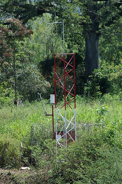 |
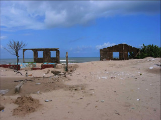
| Destruction due to Flooding in Honduras | System Radio Tower in Honduras |
This project examines solutions that avoid extensive calibration data, are computationally feasible on a microcontroller-based sensor network, and accept the limited number of sensors available for such systems. Currently, the project application is river flooding, predicting river flow using machine learning techniques, performing online calibration, and requiring less than a year to become accurate. The sensor network system consists of a limited number of precipitation, temperature and pressure sensors connected in small networks via 900 MHz radio. These small networks are connected via 144 MHz radios, which also connect the offices and communities needing the prediction and information. A prototype of this system is being developed on the Rio Aguan in Honduras concurrent to the prediction research.
To develop the initial model, we are working with 7 years of precipitation, air temperature and river flow data from the Blue River in Oklahoma [1]. Using a subset of the data, we extract features, identifying trends within each variable over a set of scaled values. We then project the original data using the feature set to predict river flow for up to 48 hours in the future. This results in a prediction scheme that does not need to know about the underlying geography of the basin or current physical properties such as soil type, but rather uses machine learning techniques to transform a small number of observations into a reasonably accurate prediction of flow, allowing flood prediction to occur.
Unlike most networks, ours examines architectures using limited amounts of sensors and large geographic regions. We designed a heterogeneous system able to monitor a region of 10000km2 and measure a wide variety of physical phenomenon. The network adapts to the data measurements and power constraints to maintain system connectivity and ensure event detection, which we define as the two key goals of system operation. Our first prototype instantiation monitors precipitation, air temperature and river level in northern Honduras in a large, flood-prone river basin. Currently, the system consists of four 144 MHz nodes, connecting two river pressure sensors to two offices. We designed and built 900 MHz sensor boxes to add to river pressure node systems, thus fleshing out the network. We will carry out a field experiment with these units along the Rio Aguan in March 2007.
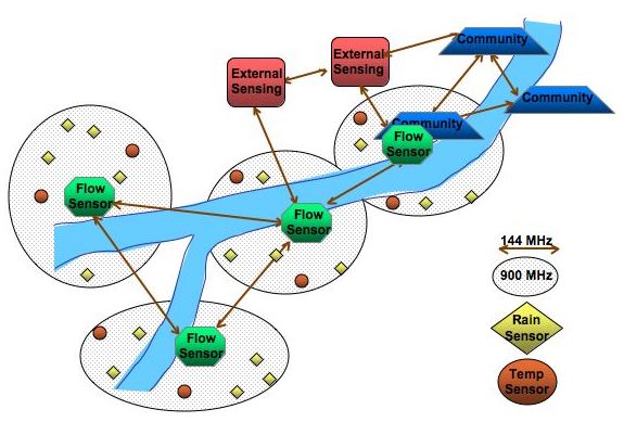
Sensor Network Architecture Consisting of Two Communication Tiers:
144MHz Flow Sensor, External Internet and Community Nodes,
& 900MHz Precipitation and Air Temperature Nodes
This project is funded by NSF and Microsoft Research.
[1] M. B. Smith, D. J. Seo, V. I. Koren, S. M. Reed, Z. Zhang, Q. Y. Duan, F. Moreda, and S. Z. Cong. The distributed model intercomparison project (DMIP): motivation and experiment design. In Journal of Hydrology, Vol. 298, No. 1/4, pp. 4-26, 2004.
The Stata Center, Building 32 - 32 Vassar Street - Cambridge, MA 02139 - USA tel:+1-617-253-0073 - publications@csail.mit.edu |